The Beginning:
Göbekli Tepe is an artificial mound located on the highest point of the Germus mountain range, in southeastern Turkey, a few kilometers from the modern town of Şanlıurfa. It towers 750 meters above the Harran plain and measures 300 meters in diameter, spreading over an area of about 9 hectares with a height of 15 meters. This mound is formed of the debris of monumental constructions dating back to the 10th and 9th millennia BC. The site was first discovered by the Universities of Chicago and Istanbul in the 1960s and was noted for the remarkable amount of flint flakes, chips, and tools. However, it was not until Klaus Schmidt's rediscovery in 1994 that the architecture of the site was recognized.
The Younger Dryas and the Origins of Göbekli Tepe: Who Built It? | Ancient Architects
The excavations started the following year and have continued, revealing an impressive monumental architecture of the early and middle Pre-Pottery Neolithic (PPN), between 9600-8000 calBC, not suspected in such an early context. The excavations have also shown that the site was not a settlement but rather a place of cult and ritual. After his death in 2014, work continued as a joint project of Istanbul University, Şanlıurfa Museum, and the German Archaeological Institute, under the overall direction of Turkish prehistorian Necmi Karul. Göbekli Tepe was designated a UNESCO World Heritage Site in 2018, recognising its outstanding universal value as "one of the first manifestations of human-made monumental architecture".[5] As of 2021, less than 5% of the site had been excavated.
The Most Impressive:
The most impressive part of Göbekli Tepe's archaeology is the PPN A enclosures. A geomagnetic survey including ground-penetrating radar has shown that more than ten large enclosures existed all over the site, not just in a specific part of the mound. Five of these monumental structures, numbered A to I in the order of their discovery, have been located in the main excavation area, while Enclosure F is at the southwestern hilltop and Enclosure E is at the western plateau. Enclosures H and I are located in the northwestern part of the site. Two enclosures, C and D, could be excavated to ground level in recent campaigns.
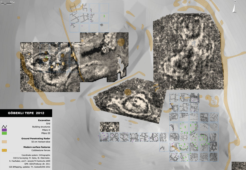
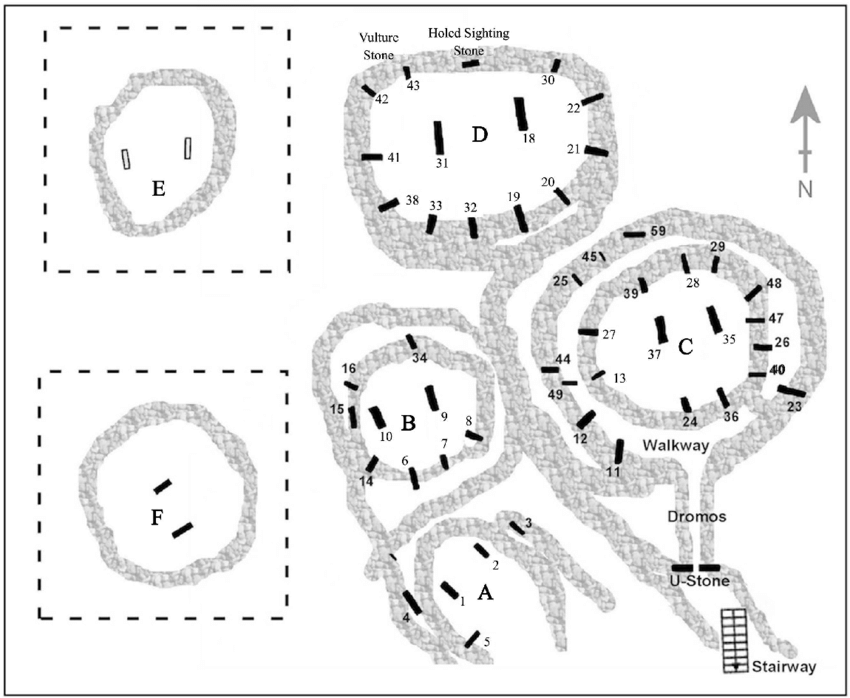
Enclosure D is the largest and best-preserved so far, with two huge central pillars measuring about 5.5 meters in height and weighing some 8 metric tons. The central pillars of Enclosure D demonstrate the anthropomorphic appearance of the T-shaped pillars, which can be regarded as abstract depictions of the human head and smaller side representing the face. Arms on the pillars' shafts with hands brought together above the abdomen are clearly visible. These T-shaped pillars own an anthropomorphic identity and are decorated with depictions of animals and various figurations, including the motives of boar, aurochs, gazelle, wild donkey, and larger carnivores.
Pillars:
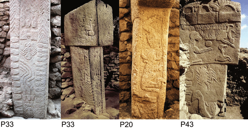
The site has three layers, with Layer III (10th millennium BC) being characterized by monolithic T-shaped pillars weighing tons that were positioned in circle-like structures. The pillars were interconnected by limestone walls and benches leaning at the inner side of the walls. The T-shape of the pillars is an abstract depiction of the human body seen from the side, with low relief depictions of arms, hands, and items of clothing on some of the pillars. Evidence for this interpretation is also seen in the sculptures of humans and animals found at the site. Layer II, dating to the 9th millennium BC, is not characterized by big round enclosures but by smaller rectangular buildings with reduced numbers and heights of pillars. In most cases, only the two central pillars remain, with the largest measuring around 1.5 meters. Layer I is formed of big accumulations of sediments produced partly by natural erosion but mainly by modern farming activities at the ruin hill
3D-Model:
Modeling Göbekli Tepe | National Geographic
Further Information:
- One of the most major works is Göbekli Tepe by Klaus Schmidt who was an influential figure in the excavations.
- If you want another book advice, you can enjoy Gobekli Tepe: Genesis of the Gods: The Temple of the Watchers and the Discovery of Eden By Andrew Collins.
- There is a documentary named Gobeklitepe: The World’s First Temple.
- For Netflix lovers, we can suggest Atiye (The Gift).
- As for the article, you can read Gobekli Tepe: The World’s First Temple? by Andrew Curry.
- If you are into podcasts, you can find The Göbekli Tepe Debate-Joe Rogan Experience from Youtube.
- A Beginners guide to Gobeklitepe, what does zero point in time mean?
- Zeropointintime
- Ancient Apocalypse episode 5 - Legacy of the Sages - This is a 2022 documentary series about the pseudoarchaeological conspiracy theories of British writer Graham Hancock. See IMRG for more info.